Google Maps' Street View feature launched 12 years ago and by late 2019 the Google Maps team announced the service had photographed more than 10 million miles around the world.
But what does that take? Cheddar got an exclusive ride in the front seat of a Street View vehicle in New York City — and sat down with Andrew Lookingbill, engineering director at Google Maps, and Ethan Russell, the director of product management at Google, to find out.
The Car and the Beanstalk
First things first, cars used for Street View vary from region to region. In New York last week we rode in a Honda HR-V.
The periwinkle crossover was parked in a garage a few blocks from Google's headquarters in Chelsea. The company wants to make it super clear what the car is doing (taking pictures!) so if you miss the 2-foot pole sticking out from the roof, there are prominent Street View logos on the back and sides of the car.
As has been documented and disclosed in the past, the actual imaging hardware of the car includes seven high-definition cameras at the top of the pole then, moving down, two LIDAR (Light Detection and Ranging) sensors, and two additional side-facing, high-definition cameras.
The first seven cameras capture images to be stitched together later. The LIDAR enables 3D imaging in 360 degrees (also found on most autonomous vehicles). The two side-facing cameras enable Google to capture details about street and store signs that can ultimately generate new listings on Google Maps automatically. More on that later.
A computer on the floor of the back seat stores the captured data that is then processed and stitched together later at Google's offices.
In the front seat, there's nothing more than a display that shows the driver what information has been collected. Google calls these "breadcrumbs" which ultimately take the form of a blue line representing the route driven.
Lookingbill explained that they wanted to keep the interior as simple as possible to minimize driving distractions.
The Trip
Driving around is the easy part.
Street View cars only operate in sunny or cloudy conditions. Rain, sleet, and snow obstruct images (self-explanatory).
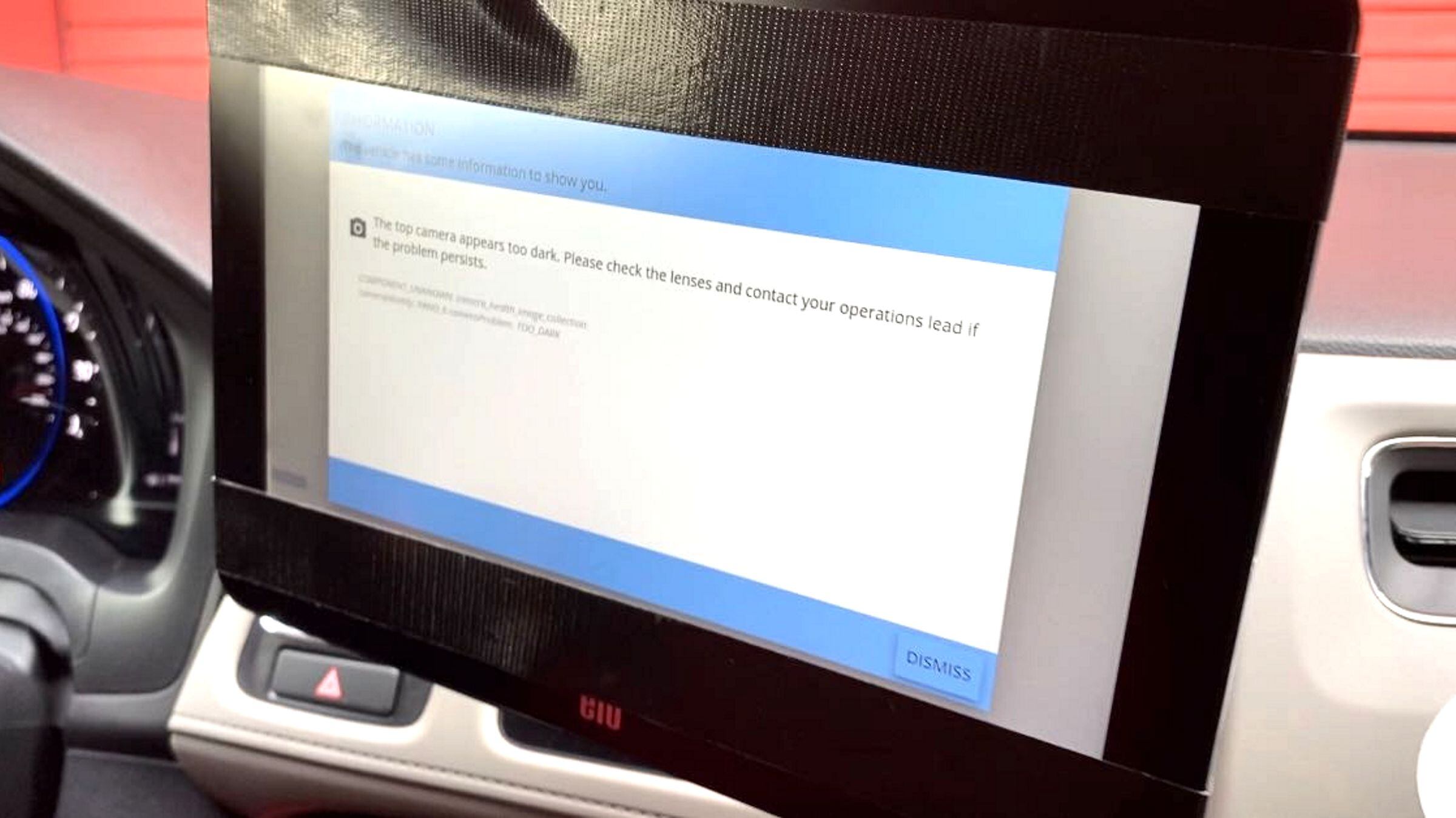
If something does obstruct a lens, the screen shows a message to the driver. Sometimes a simple tap will clear the warning, but, if not, the driver will get out to check the equipment.
On my drive, a message appeared as we pulled back in the garage due to low visibility (low light).
My driver, Regina, kept a small step ladder in the trunk along with a towel.
Drivers are on the road in shifts, which vary by location and can run between eight and ten hours a day in New York, for example.
The Trekker
The effort to obtain Street View for 98 percent of the world is not just a four-wheeled operation. Google also recruits trained individuals and sends employees to collect images of more challenging locations, such as volcanoes, mountains, and the Great Barrier Reef.
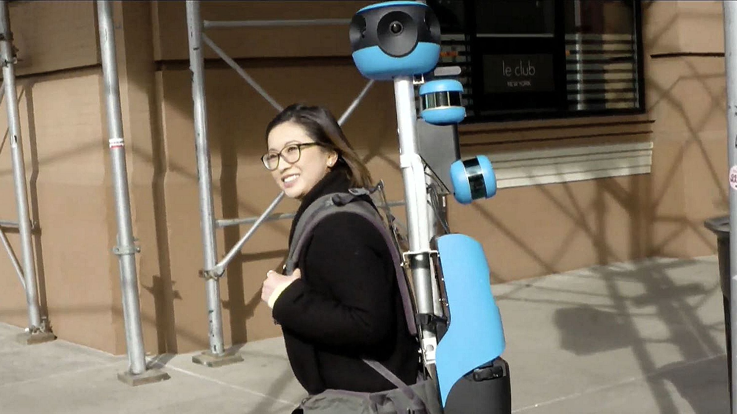
They strap a portable device similar to the beanstalk on the Street Vehicle car on their backs. That has seven HD cameras, two LIDAR sensors, and weighs in at about 40 pounds. I walked roughly a city block with one on and, having never really hiked, I felt those 40 pounds for sure.
Google also builds variations of the trekkers on snowmobiles and mopeds.
The Significance
Google Maps is used by more than one billion people every month.
The app has grown to include more features that make Google more money: Need a hotel? Search for it on Google Maps and book directly. Find a restaurant you like? That's a local business that has bought a Google ad.
For this reason, Google Maps needs to be as up-to-date as possible and the technology on Street View allows that to happen. Cameras and software can recognize changes and read signs, which allows them to do things like auto-generate new business listings. "Businesses going in and out of business, roads changing, temporary stoppages -- we have to stay on top of that," Lookingbill said. "That's how we've reached this balance between information coming from users, our local guides, our large community of Maps users who are reporting problems as they see them, and our algorithms looking at clues from imagery and other sources." With high-resolution satellite imagery as the base for street layouts first, Lookingbill says the company often refers to the entire process of building Google Maps with Street as "a layer cake."
Given Google's parent company Alphabet still makes the majority of its revenue through advertising (85 percent as of the third quarter of 2019), local listings and maps are key parts of making Google more useful.
"Ads in Maps are designed to integrate seamlessly into the natural Maps experience and we closely monitor how users respond to provide the best experience possible," Google says.
The company has also been encouraging businesses to build their own Street View content, arguing mapping features help drive in-person visits.
Final thoughts
Like all recent technology stories, the magic of an operation like Google Maps lies not in the hardware but the software.
In this case, the trip in the Street View car wasn't by itself exciting, but it is the data collection part of the work that makes it special. The processing that stitches images together and gets maps to look seamless all happens in the mapping software. Until we can shrink ourselves down to a quantum level of Ant-Man or something similar, we may never fully appreciate all of the engineering behind the services we use.


